Wider area and direct vicinity
The subject area belongs to the central zone of Belgrade, which includes the historical center of Belgrade - "town in a trench", Terazije, Slavija, Svetosavski plato, the port of Belgrade, the Sava amphitheater and Prokop.
This whole reflects the historical development and growth of the city from the city nucleus - Belgrade Fortress, Belgrade ridge and Kralja Aleksandra Street to Smederevo Road and growth to the banks of the Sava and the Danube. It developed in the old city center, forming a matrix of compact blocks with fully defined parcelling, regulation of streets and buildings with mostly marginal construction and associated open public spaces. In terms of capacity, the center of Belgrade still remains the area of greatest concentration of residents, employees, built facilities and attractive functions. According to urban characteristics, typology of construction, monuments, ambient and other values, this whole represents the most complex and most attractive area of Belgrade.
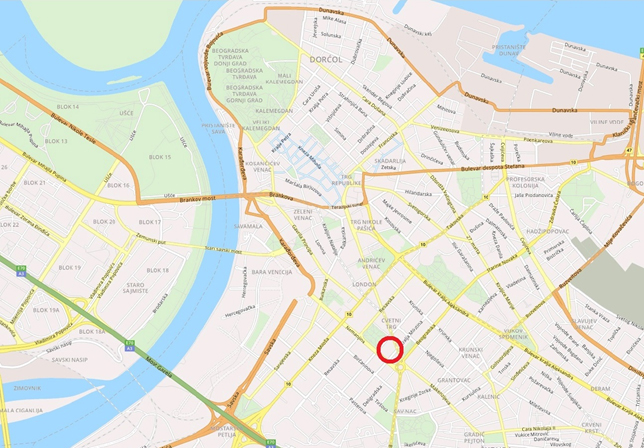
Figure 3 - location of the location in the wider environment
Most of the territory of the center of Belgrade is defined as a permanent property of Belgrade. Cultural properties of exceptional importance, cultural properties of great importance, cultural properties and properties that enjoy prior protection, fixed elements of greenery, archeological sites of all ranks of protection, protected views, streets located in the center are the elements that are dominant in relation to general and special rules for the construction and arrangement of space.
The existing clearly articulated area of mixed central functions, areas of public purpose and content, formed from the historical core - "towns in a trench", towards Slavija and Bulevar kralja Aleksandra, is continuously supplemented with new central and public contents of the highest rank. New facilities are planned on the banks of the Sava and Danube, as well as in the immediate contact area.
Concentrations of central activities are also planned along the transverse connections between the coasts, mainly in the existing streets, connecting the traditional center with attractive points on the coast. In addition to the most important public urban spaces along the main city routes, such as Kneza Miloša Street, Takovska Street, Despota Stefana Boulevard, Cvijićeva Street, Dimitrija Tucovića Street, Belgrade Street, Jugoslovenske armije Boulevard and others, the most important connecting and transverse routes in this zone are Kralja Petra Prvog Street, Francuska street, Brankova street, Balkanska street, Nemanjina street, Rooseveltova street, Mije Kovacevica street and others.
The center of Belgrade is characterized by edge construction in formed blocks with mixed purpose. The combination of housing, commercial and public facilities of significant storeys is characteristic of the zone of the center of Belgrade and forms the predominant urban fabric. The planned network of representative commercial and central contents includes quality public spaces and, as such, should become the initiator of the renewal of the existing inactivated parts of the city matrix of Belgrade.
Representative city area Manjež – Slavija
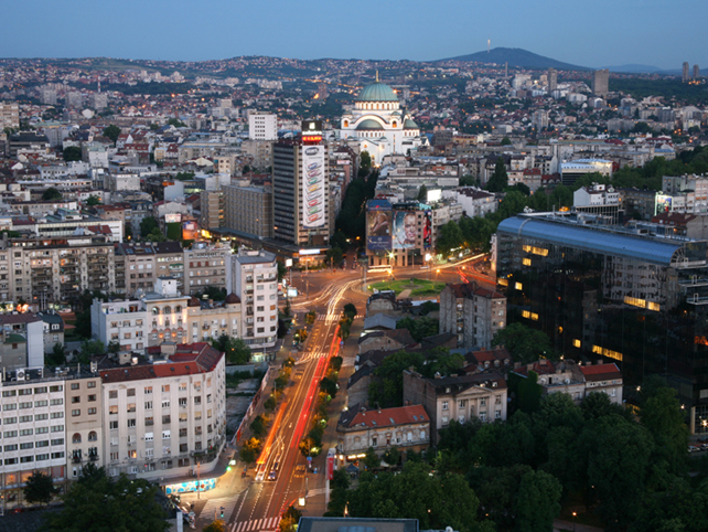
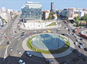
The area of Slavija belongs to the central zone of Belgrade and according to the relief it represents a part of the most important city route on the area Kalemegdan - Slavija and further to the Vracar plateau. This area represents the most significant longitudinal monumental ambient value that ends with a powerful traffic node, the "Autokomanda" intersection. The focus of this area is Slavija, one of the most important traffic nodes in Belgrade, where transit, destination and local trips that gravitate to the central area meet. Slavija Square is also a crossroads of public transport routes (buses, trolleybuses, trams). According to its disposition in relation to the old town, it is one of the central urban points of the central zone of Belgrade, to which the East and West Vracar converge (West Vracar today administratively belongs to the municipality of Savski Venac).
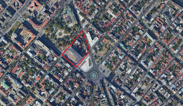
Figure 4 – broad area of Slavija Square with the marked position of the subject block
Slavija is an urban space whose morphology and physiognomy were being formed over many years in different social and economic conditions. Material evidence of the origin is preserved in the existing street format change, parcelling and buildings, some of which represent cultural-historical and architectural-urban values through which the entire development of this area is reflected. The wide sector around Slavija Square was consistently built according to the orthogonal system, with the exception of a smaller complex around Svetosavska Street, between Makenzijeva street and Bulevar oslobođenja and the diagonal extension of Kralja Milana Street.
The existing morphology and physiognomy arose as a result of often spontaneous and chaotic processes, destruction, but also deliberate urban endeavors, planned and realized gradual transformation and urbanization.
The area of Slavija, in addition to traditionally represented housing, is a center of business, commercial and social facilities. It is a zone of compact city blocks (closed blocks of edge construction) with clearly defined regulation towards the street, high population densities, indices of construction and occupancy of plots. The parcelling and height regulation is diverse and ranges from small and irregular plots with several ground floor buildings on the plot (partaje) to proper parcelling with high city buildings with trade and business on the ground floors and low-rise floors, sometimes with auxiliary buildings inside the blocks. These blocks are often characterized by an untidy interior with neglected green areas and a great lack of parking space. Housing appears in the form of family houses from the beginning of the last century, multi-family buildings of the interwar period and modern architecture of the second half of the XX century.
The wider area of Slavija is an important social and business center, with great development potential, primarily for central city and business facilities. Therefore, Slavija should be viewed as a strong multifunctional center, future plans should limit the contents of administrative business and thus reduce the discrepancy between the day, afternoon and night attractiveness of this area. Housing, traditionally represented in this area, should be further developed (apartment, luxury).
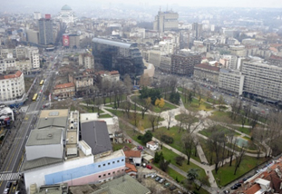
Picture 5 - view towards the Vracar plateau, 2011.
Different urban structures, including the quality of buildings and the attitude towards the environment, are a consequence of unfinished urbanization and its discontinuity. In relation to the significance and potential of the location, the space of Slavija, overall, is inadequately used, unclear and insufficiently recognizable, and the result is a decomposed and unfinished urban-morphological whole. In a broader sense, the quality of this location is the natural conveniences of the terrain and its position in relation to the dominant traffic routes and other traditional city centers.
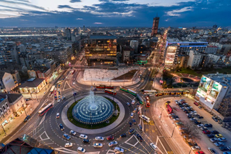
Picture 6 - Slavia Square - view towards the competition block Picture 7 - Slavia Square - view towards the competition block
© www.booking.com © Dragan Jevremović, www.politika.rs
The functional and ambient structure of immediate and wider gravity is formed by a triangle that consists of Kralja Milana Street as an important line center and shopping street, Nemanjina Street as an administrative - business center and Slavija Square as a traffic node.
In the immediate vicinity are important city landmarks: Park "Manjež", Flower Square (Cvetni trg), the Officers' Club building nowadays widely known as the "SKC”, Hotel "Slavia" and new facilities of the Yugoslav Drama Theater and Hotel "Hilton".
Park "Manjez", built in the early thirties of the XX century, was reconstructed in 2016 and is one of the rare green areas in the vary center of Belgrade. The regular rectangular shape with two diagonal paths, the park that leads to Nemanjina, Resavska and Svetozara Markovića Street, also functions as an important corridor for pedestrian traffic.
The Pjaceta, that is, the plateau of Slavija Square, is in the zone towards Nemanjina Street, uneven, amphitheatrically shaped, oriented towards the fountain.
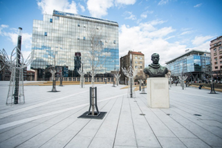
Picture 8 - Manjež Park Picture 9 -Pjaceta on Slavija Square
© D.Milenković / RAS Srbija © Milena Arsenić
The competition scope is located between the two mentioned public open spaces: the park "Manjež" along Svetozara Markovića Street and the square along Kralja Milutina Street.
Competition scope
The area of wider competition scope consists of a block located northwest of Slavija Square, between Kralja Milana street, Svetozara Markovića street, Nemanjina street and Kralja Milutina street. The part that is elaborated in more detail within the competition (narrow competition scope) includes the northeastern part of this block, ie the plots that are oriented towards the streets of Kralja Milana, Kralja Milutina and Svetozara Markovića. The plots of this block belong to the Belgrade municipality of Savski Venac, and the regulation of the side of Kralja Milana Street with even numbers represents the border between the cadastral municipalities of Savski Venac and Vracar.
The block in question is part of an orthogonal street matrix, is trapezoidal in shape and has an average area in the context of the central zone of Belgrade. With its southeastern front, along Kralja Milutina Street, it forms the northwestern facade of Slavija Square.
Within the observed scope, the regulation and construction line, as parameters that give identity to the space, coincide and form a block with edge construction and clear parcelling, which should be an important element for establishing continuity in planning interventions for construction of new facilities. The whole block is urbanistically unfinished, it has been in the process of urbanization for a long time, and the existing built structure consists of business and residential buildings of different creditworthiness and character. The construction fund documents the diversity of present forms and styles, as well as various cultural influences.
The southwestern part of the block, bordered by Nemanjina, Kralja Milutina and Svetozara Markovića streets, with its 53,000 m2, occupied an imposing building of the National Bank of Serbia. The building, floors P (ground floor) + 9 + Pk (attic), was built in 2006, after 15 years of construction.
The NBS building is separated from the rest of the block by an internal, fire-fighting road, which is the only pedestrian crossing through the block.
The form and position on the plot of the NBS building, with free treatment of all four facades of this grandiose size, provide the NBS building with the character of a free-standing building, contextual in the immediate and wider environment of the central city zone. In this sense, the NBS building certainly represents an element of discontinuity within the prevailing system of the urban environment and a constraint for future construction.
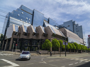
Picture 10 - National Bank of Serbia from Nemanjina Picture 11 - internal road in the block
The northeastern part of the block (narrow competition scope), between Kralja Milana, Svetozara Markovića, Kralja Milutina streets and the internal road to the NBS, is urbanistically unarticulated, characterized by high occupancy and uneven height regulation. The only common feature of the built structure of the block segment is the edge construction. The buildings have different purposes, quality and creditworthiness - from family housing with activities on the ground floor in buildings of almost a hundred years of age and without ambient values, through multi-family buildings of Belgrade interwar architecture with stylistic characteristics typical for the construction period, to newer multi-family buildings. On some plots there are several buildings, with business or residential-business facilities along the street and residential and auxiliary ones in the interior of the plot.
Due to ownership relations, but also car approaches, the transformation and replacement of buildings was least realized on the plots along Kralja Milana Street. Therefore, in that zone, the buildings are mostly ground floor or P (ground floor) + 1 with auxiliary buildings inside the block. By purpose, they are mostly family or multi-family residential and business buildings.
Along Kralja Milana Street, as a consequence of ownership relations, but also the restrictions on the vehicular passage to the plot in the context of modern regulations and needs, the transformation and replacement of buildings has been least realized. In that zone, the buildings are mostly ground floor or P (ground floor) + 1 floor with auxiliary buildings in the interior of deep plots, all of poor quality.
In Kralja Milutina Street, in addition to two residential and business buildings of lower floors, there is also a multi-family residential building of interwar architecture, storeys P (ground floor) + 5 + Pk (attic), positioned along the border of the NBS plot, so there is a kalkan on the northeast facade of the NBS.
Along Svetotozara Markovića Street, multi-family residential buildings were built, floors P (ground floor) + 3 to P (ground floor) + 7 + Ps, most often with catering facilities on the ground floor.
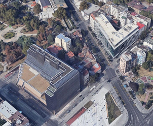
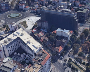
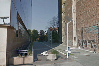
Figure 12 - view of the block towards Manjez Figure 13 - view of the block towards Slavija
On the ground floor of one of these buildings (on cadastral parcels 1033 - cadastral municipality Savski venac) there is one of the oldest restaurants in Belgrade, the famous cafe "Manjez", which began operating in 1922. For decades, the traditional Serbian tavern was considered a very prominent place visited by artists, journalists, politicians, as well as foreigners who come to Belgrade.
In the entire area of narrow competitive scope, in the period after the Second World War, only one building was realized, in accordance with the conditions of the Detailed Regulation Plan in force - in Svetozara Markovića street, no. 45 (cadastral parcels 1030, cadastral municipality Savski venac), a multi-family residential building with business on the ground floor , floors P (ground floor) + 7 + Pk (attic).
Vehicular passage to the plots are realized exclusively from Svetozara Markovića and Kralja Milutina streets, except for the building of the National Bank of Serbia with access ramps for the underground garage from Nemanjina street, outside the Bank's plot, ie. on opposite sides of Kralja Milutina and Svetozara Markovića streets. The new facility at Svetozara Markovića str., no.45 and the National Bank of Serbia are solving the parking needs within the NBS underground garage and at a dozen open parking spaces along the internal / fire-fighting road. Other parking needs are being solved, mostly in the street parking lots in Svetozara Markovića and Kralja Milutina streets.
The interior of the block is untidy and inaccessible, with low-rise ancillary buildings and smaller green areas. The most valuable and most dominant category of greenery is represented by tree lines that exist in all perimeter streets.