History and development of space, architectural and cultural heritage
Space development
Vracar is one of the central municipalities in Belgrade, which stretches along the northwestern hilly side of the Vracar hill, mostly of a residential character. The southern side of this plateau descends towards Čuburski potok (today Južni Bulevar (South Boulevard) street), while towards the northwest it extends into Terazije ridge, which ends steeply on the banks of the Sava and the Danube rivers.
This part of Belgrade was formed between the most important (in the period of initial urbanization of this area) communications: Constantinople and Topcider roads. The mentioned traffic routes are still in frequent use, on the routes of Bulevar kralja Aleksandra and Kneza Miloša Street and still represent generators of development. The third road, Kragujevac road, which was preserved in the direction of Kralja Milana Street and part of Bulevar oslobođenja, divided the area of Vracar as it does today, into East and West Vracar. Today, West Vracar administratively belongs to the northern part of the municipality of Savski Venac.

Figure 14 - Plan of Belgrade from 1878, ing. Stevan Zaric with the marked position of the subject block
The border between East and West Vracar, ie the border of the cadastral municipalities of Vracar and Savski Venac in the area covered by the competition, is Kralja Milana Street.
The history of the continuous development of this area can be traced back to the middle of the 19th century. Along with the works on the reconstruction of the old town in the trench and on the transformation of Terazije into the center of the capital, the city gradually expanded beyond the last city district streets - Katićeva street and Beogradska street at that time. The process of forming West Vracar began in the 1840s with the famous plan of Franz Janke. Within the territory itself, and closer to the zone of connection with East Vracar, some streets were of greater importance from the very beginning, and others of less importance. These were mostly streets with a strict residential character, significant views towards the Sava river or Slavija, and their architectural structure consisted of one-storey houses or those with a high ground floor, sometimes in the form similar to the type of city villa. The remains of this heritage are still read today, supplemented by objects of interwar and modern architecture.
At the exit of Kragujevac Road from the city region, at the end of the 70s of the 19th century, a smaller triangular non-parceled terrain was formed, as the beginning of the future Slavija Square. On the plans of Belgrade from 1884 (Fig. 15) and 1896, the corner of Makenzijeva and Svetosavska streets was drawn deep across the southeast, which created space for a possible new square.

Figure 15 - Plan of Belgrade from 1884, with the position of the subject block
Another important moment in the development of Slavija was the adoption of the General Plan of Belgrade in 1908, when the architect Alban Chambon introduced the characteristics of French urbanism and with the aspiration for larger axial compositions gave importance to the Slavija - Terazije - Kalemegdan axis. As part of such a concept, he plans a circular star-shaped Slavija square with a triumphal arch in the center and ends that monumental axis at the highest elevation, the temple of Saint Sava.

Figure 16 - Plan of Belgrade from 1923, Đorđe Kovaljevski, with the marked position of the subject block
With the construction of public buildings, the Hotel Slavija (1888) and the Peace Hall (1889), as a kind of cultural center, the situation on Slavija was partially clarified. With the adoption of the General Plan in 1923, Djordje Kovaljevski defined the current regulation of the square with a circular island (Fig. 16). With the intensive construction of the area between the two wars, the old construction fund was replaced, but a smaller number of single-storey houses were left, which were in the forefront. The buildings from that period belong to different stylistic directions, they are characterized by the characteristics of eclectic and modern architecture.
In the last decades of the 19th century, the area of Vracar, initially of an economic character, thanks to the arrival of new owners who started the subdivision of land for the construction of family houses, suddenly grew into a residential area. The change of purpose in this part of Belgrade had a direct impact on the urban structure of the area with consequences that last to this day.
The historical presentation of the development of this area shows that the process of modern Serbian urbanism outside the so-called "Town in a trench" began. Just in Vracar (West and East). By adopting the inherited communication directions, in the middle of the 19th century, a system of orthogonal scheme of street regulation, internal communication and arrangement of buildings was realized in this territory. Therefore, this space can be recognized as a kind of constructed symbol not only of the urban transformation of the capital, but also of the social emancipation of the local community, ie as an example of newly established social and communal relations. This is evidenced, among other things, by private houses and buildings that were being built along the edge of Slavija Square since the 1980s and which were shaped in the spirit of European architecture of historical styles and represented visual benchmarks and important contents of the bourgeois identity of that time.
The history of Belgrade tram traffic has begun, also encompassing this area. The first Belgrade tram with a horse-drawn carriage was put into traffic in 1892, and it ran on the route Kalemegdan - Slavija. This line ran under number 1, and soon line 2 started from Slavija to the Officers House, and through Nemanjina street to the Railway Station.

Picture 17 - aerial shot of Slavija, from Aleksa Nenadović to Resavska, 1930s
Between the two world wars, almost nothing was built on Slavija.
In 1942, during the German occupation, a roundabout was built on Slavija and the drainage of wastewater to the Sava River was regulated, which is still in function today.
In the period after World War II, Belgrade developed mainly on free areas and spread around the old city fabric, somewhat neglecting the reconstruction of the city center. Despite that, intensive planning was done in the area of Slavija, a large number of urban proposals were given for the solution of this area, but it is characteristic that a very small part was affirmed through the realization. Practically, the development was reduced to remodeling the space, edge construction, and closing and thickening the existing blocks. Over time, minor interventions and additions were made that did not contribute to the understanding of the overall solution, so phasing and gradualness were the ways to realize this area. The space developed in segments, plot by plot, in accordance with current social needs.
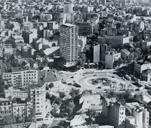
Picture 18 - aerial shot of Slavija from Svetozar Markovic to Vracar, 60s of the XX century
Slavija Square changed its name to Dimitrije Tucović Square in 1947, and in 1949 in the center of the square, on the grassy central space, a bust of Dimitrije Tucović, the leader of the labor movement and the founder of socialist ideas and the social democratic movement in Serbia, was placed. Beneath the bust were his remains. After the reconstruction of the square in 2017, the monument and the bust were moved, and a fountain was built in their place. In 2000, the name Slavija was returned to the square.
The plan for the reconstruction of the central zone of the city, made as part of the General Plan of Belgrade in 1950, dealt with some significant city areas, including Slavija (Dimitrije Tucović Square). Based on the Regulatory Plan, the Slavija Hotel was built in 1962, which was expanded and extended in 1989.
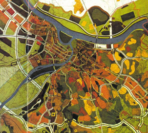
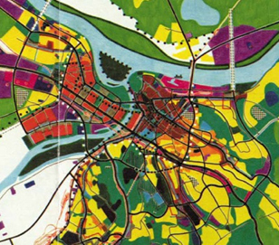
Figure 19 - GUP of Belgrade in 1972., A.Đorđević and M.Glavički Figure 20 - GUP of Belgrade in 1985., Konstantin Kostić
General urban plans (1972 and 1985), as well as plans, studies and analyzes that represent their further elaboration, define Slavija as one of the priority areas for development. The spatial and program concept of Slavija is seen within the framework of a predominantly business and shopping center with an emphasis on the creation of pedestrian spaces and ambiences, simplification of surface solutions and a new functional organization of underground and aboveground structures.
Similar spatial-planning determinants are taken over by the General Plan of Belgrade from 2003, which envisages that the contact blocks around the square will be in the function of commercial and business activities and housing in a compact block with differential shopping streets and boulevards. The general characteristic of the space should strive for a large involvement of public space and central contents.

Figure 21 - General Plan of Belgrade from 2003, V. Macura and M. Ferenček, with the position of the subject block plotted
Architectural and cultural heritage
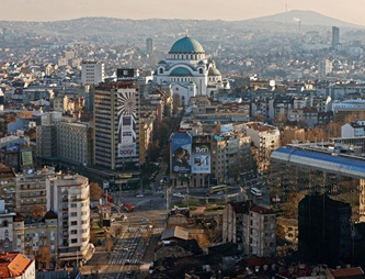
The area of Slavija, according to its disposition relative to the old city center, is one of the central points of the central Belgrade zone, whose period of urban development lasts for almost 200 years. As part of the essential city route - Kalemegdan - Slavija to Vračar plateau, it has a high hierarchical significance and exceptional value in the urban city core. Elements of heritage in this area are the street matrix consisting of a network of streets with existing parceling, the characteristic shape of the square itself, the silhouette, and specific objects of interwar architecture.
Many buildings have been erected near the competition scope that stand out by their position in this city part view.
The house of Josif Šojat (33 Kralja Milutina) is located in the continuation of Kralja Milutina Street towards Njegoševa Street, relative to the competition location. It was declared as a cultural monument (Decision on Proclamation, "Official Gazette of RS" No. 65/19) with an exceptional cultural-historical and architectural-urban value and included in the immovable cultural property of the city of Belgrade. According to the design of architect Milan Zloković, it was built for the Belgrade investor and owner Josif Šojat, as a building with apartments for rent and shops on the ground floor, in 1927. The building forms a modernized structure with stylistic elements of Renaissance palaces of central and northern Italy and relief accents inspired by the Baroque and Mannerist eras. As a work created by the interaction of architecture, sculpture, and painting, the house of Josip Šojat is a unique example of Belgrade's residential architecture of the first half of the 20th century. It is a rare example of art deco style that contributed to this style affirmation in Belgrade and Serbia between the two world wars. Although one of the early works of architect Zloković, pointing to his historicism to modernism transition phase, the house of Josip Šojat is one of the most significant works of this author.
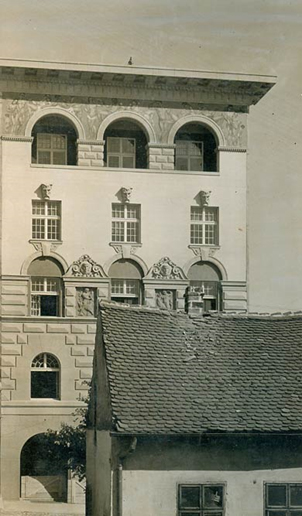
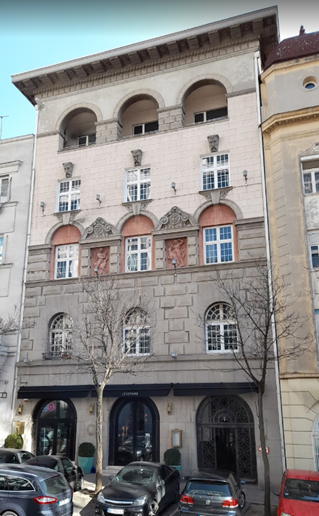
Picture 22 – Josif Šojat Building, 1926. Picture 23 - Josif Šojat Building, today
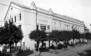
The Yugoslav Drama Theater (50 Kralja Milana), although sixty meters away from the competition location towards Resavska Street, is an immediate neighbor of the future construction from the aspect of the built structure. It was initially built around 1860 and represents an immovable cultural property, a cultural monument, as a property that occupies an exceptional place in the development path of the Serbian theater (Decision on Proclamation, "Official Gazette of the City of Belgrade RS" No. 23/84).
The block in which the Yugoslav Drama Theater and Manjež Park are today served the Royal Cavalry Guard during the Principality of Serbia; there were stables and barracks, and on the site of today's Yugoslav Drama Theater building was the Household Cavalry Regiment manege. Following the First World War, due to the war-damaged home building, the ensemble of the National Theater moved into a simple, one-story manege building. However, already in 1927, the "Wooden Manjež" completely burned down in a fire. In the same year, according to the plans of architect Nikolaj Krasnov, the theater building construction began on the burned manege site. From 1929 to 1931, there was a "Theater - Building in Vračar." Then, space was temporarily adapted for the National Assembly. Assembly sessions were held there until 1937 when the building was re-adapted for the needs of the theater, newly named "Vračar Theater." Since then, the building has been continuously used as a theater.
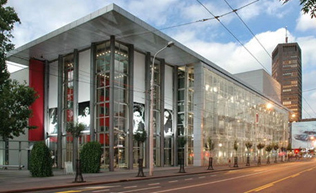
After the Second World War, in 1947, according to the design of architect Momčilo Belobrk, the "Manjež" building was again adapted and reconstructed, following the new socio-political ambiance. The building of the Yugoslav Drama Theater, which has since received its official new name, was a monumental modernist work, with a simple and unornamented facade and entrance porch. A particular accent was on the atrium (porch), in the central part of which there was a decorative pool with a bronze figure, the work of sculptor Boris Kalin.
In 1997, a fire broke out again in the former Manjež building, destroying the Grand Stage and almost the entire Yugoslav Drama Theater building. Based on the first-prize winning competition solution, by architects Zoran Radojičić and Dejan Miljković, the YDT building was reconstructed, modernized, and thoroughly renovated in the spirit of modern architecture. The current visual identity of the Yugoslav Drama Theater, although completely new compared to the previous ones, by retaining the basic idea of architect Momčilo Belobrk in the entrance porch and incorporating and "exhibiting" the facade of architect Nikolaj Krasnov, is homage to previous visual identities or the above architects.
Picture 24 - YDT, 1930. Picture 25 - YDT, today © MGB
"Slavija" Hotel (1-9 Svetog Save street) has dominated Slavija Square since the 1960s. It was built in 1962, on the corner of Makenzijeva and Svetog Save streets, according to the design of architect Bogdan Ignjatović, as a "commercial hospitality facility for guests who do not stay in the city for long." Positioned as the tallest of several towers, planned by the then urban plan, in the vicinity of the square, on the site of the hotel of the same name built in 1885 (architect and engineer František Nekvasil), which was destroyed in the 1941 bombing. Today, the recognizable 17 story tower bears the new name Slavija I and is part of the hotel complex, which, apart from it, comprises the significantly lower buildings Slavija II and Slavija III.
Picture 26 - "Slavija" Hotel, 1960. Picture 27 - "Slavija" Hotel, today
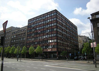
The Social Security Building in Belgrade (30 Nemanjina) is located on the corner of Nemanjina and Svetozara Markovića Streets. It was declared a cultural monument (Decision on Proclamation, "Official Gazette of RS" No. 37/13) with architectural, urban, and cultural-historical values and included in the immovable cultural property of the city of Belgrade. It was built in 1962 according to the design of architect Aleksej Brkić, whose works were among the first to mark the new stage of Belgrade's construction. The geometric façade composition stands out on the building - construction, cubic perfection of volume, graphics of a black metal grid incorporating windows and dividing polychrome parapets. Apart from being one of the most valuable works in his oeuvre, it depicts the most significant elements of Brkić's architectural work. The Social Security Building is the only work in Serbian post-war architecture where polychromy came to full expression and occupies a prominent place in the history of modern Serbian architecture.
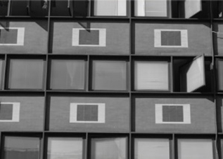
Picture 28a - Social security building Picture 28b - Social security building, facade detail
The National Bank of Serbia (17 Nemanjina street) is located on the corner of Nemanjina, Svetozara Markovića, and Kralja Milutina Streets. It was built in 2006, according to the design of Zagreb architect Grujo Golijanin, modeled after the world architecture of commercial buildings, current in the seventies and eighties of the last century - buildings whose visual identity is defined by materialization dominated by structural façade and tinted glass, the so-called "crystal palaces."
The building with 11 above-ground and four underground floors, complex functions and facilities, with modern management and security technology, is one of the so-called "smart buildings."
This building is part of a wider competition scope.
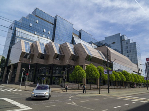
Picture 29a - NBS building from Nemanjina Street Picture 29b- NBS building from the Slavija Square piazzetta
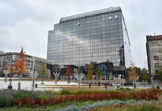
"Hilton Belgrade" Hotel (Kralja Milana street 35) on the corner of Kralja Milana and Kralja Milutina streets is the last one built in a series of buildings that ambiently determine the immediate environment of the competition scope. The hotel was completed in 2018, according to the design of architects Igor Marić, Božidar Manić, Aleksandar Sudžuković, Bojan Zabukovac and Zoran Mrvaljević. The building structure comprises nine above-ground and four underground floors. The visual character of the building towards the public space is defined by a dynamic segment facade that fits the environment and a pronounced sharp corner of the higher floors towards the corner of Kralja Milana and Kralja Milutina streets.
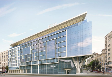
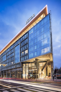
Figure 30a - Hilton Belgrade Hotel Figure 30b - Hilton Belgrade Hotel
© www.belgrade-beat.rs © Miloš Martinović
On the other hand, some locations in the immediate vicinity, despite numerous attempts, have not been realized to this day. The most famous is certainly the so-called Mitić's hole - most of the block covered by Kralja Milana, Beogradska, Njegoševa and Kralja Milutina streets, within which only a series of plots along Kralja Milutina Street is under constructed buildings, while the rest of the space is "temporarily" landscaped. The name Mitić's hole is due to the first in a series of unsuccessful attempts to realize construction in this area. In 1938, merchant Vlada Mitić, as the then new owner, intended to build a "Mitić magazine" in this area (a department store with accompanying contents intended for entertainment). "Mitic's magazine", with a planned height of 70 meters, was supposed to be the tallest building in Belgrade (Figure 30). In 1940, the existing buildings were demolished and construction began, but soon, following the onset of the Second World War, it was discontinued.
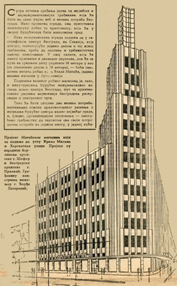
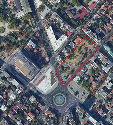
Figure 31 - Mitić's magazine, "Vreme," 1940. Figure 32- "Mitić's hole," today
From 1946 to 1980, this space was the subject of as many as 26 different projects, but none was implemented. Until the mid-eighties of the last century, the area of Mitić's hole was completely unarranged, and there was a parking lot in the part towards Njegoševa Street. During the mayor of Belgrade term of architect Bogdan Bogdanović, in 1985, the part towards the then Maršala Tita Street (today Kralja Milana) was landscaped and a large sundial was set. The sundial was removed in 1992 for another construction attempt, this time of "Dafiment Center", according to the first-prize winning competition solution of academician and architect Milan Lojanica. However, as previosuly, it was not realized. The current phase of preparing the DRP for the area between Kralja Milana, Beogradska, Njegoševa and Svetozara Markovića streets implies new construction attempts on the Mitić's hole site in the near future.
Studies, competitions, planning documents
The process of forming the urban core and planned development of Western and Eastern Vračar began in the middle of the 19th century as part of the implementation of the initial ideas of Belgrade urban reconstruction, which then began to expand beyond the trench and strive for a new urban character, like other European capitals. Until the Second World War, the development of this area was intensive but not always continuous nor consistent. Belgrade spread primarily on free surfaces in the second half of the 20th century, outside the old city core, neglecting reconstructions. The old core stagnated, beginning to collide with the functions and needs of the whole.
However, from the beginning of its development, until today, the area of Slavija Square with the immediate/wider environment has been the subject of continuous public and commercial interest of the professional public and potential investors. This space has been the subject of many analyzes, studies and reviews of urban and architectural concepts, both through competitions and through long models of expert opinion presentation. In accordance with the above, a series of urban proposals for solving the entirety of this zone, through revitalization or reconstruction of space, as well as numerous architectural and urban designs for individual plots and locations in blocks around the square emerged. However, despite the large number of studies, urban plans and competition designs for the subject area as a whole and its segments, the percentage of those confirmed through the implementation is small, and the area of Slavija has remained spatially unshaped to this day.
Apart from testifying to the complexity of the subject space and the need to affirm own image of the environment within the current context, all of the above is indisputable generational confirmation of the complexity of various influences that result in discontinuities in urban development and final shaping of Slavija.
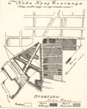
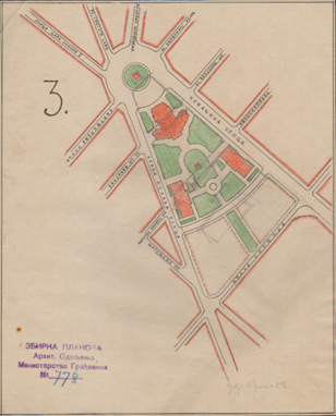
Figure 33 - Plan of the Englishman, Francis Mackenzie, 1886. Figure 34 - Plan of Slavija Square between 1930 and 1941.
Source: Urbanism of Belgrade, No. 66-67
During the preparatory and analytical phase of the first post-war General Urban Plan of Belgrade (adopted in 1950), several studies of the reconstruction of Dimitrija Tucovića Square with the gravitational environment were presented, and research into optional solutions continued after the GUP adoption.
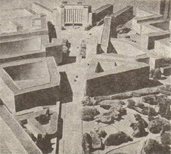
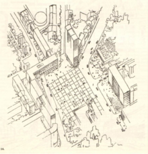
Figure 35a - Proposal for reconstruction of D.Tucovića Square Figure 35b - Proposal for reconstruction of D.Tucovića Square,
Arch. N. Gavrilović, applied in GUP, 1950 Arch. B. Stojanović, 1951
Source: Urbanism of Belgrade, No. 66-67
Figures 36a and 36b - Proposal of the urban design for the reconstruction of D.Tucovića Square, Urban Institute of Belgrade,
Arch. Nikola Gavrilović, Arch. Vesna Matičević and Arch. Dušanka Menegelo, 1957
Source: Architecture Urbanism, No.13
General Yugoslav Competition for the conceptual design of a department store on Dimitrija Tucovića Square in Belgrade - a block between Boris Kodriča (Beogradska), Maršala Tita (Kralja Milana), Svetozara Markovića and Njegoševa streets in Belgrade (1964). The conditions of the competition envisaged an independent segment intended for administrative and commercial contents within the department store building. They did not allow emphasis on the new building, but "a certain calming of the entire block and fitting the existing ones into the new building". 27 works were submitted to the competition. The Jury unanimously decided that the competition as a whole did not give the expected results, and that the best ranked works did not provide all the necessary qualities for competition recognition by awarding prizes. Still, a decision was made to buy seven works that entered top three categories 3 + 1 + 3 equally in each.
Figure 37 – Competition design, Arch. Dušan Milenković Figure 38 - Competition design, Arch. B.Hajdin, S.Fotirić
Overview of works (first) from the General Yugoslav Competition for the conceptual design of the department store in the block between Borisa Kodriča (Beogradska), Maršala Tita (Kralja Milana), Svetozara Markovića and Njegoševa streets in Belgrade
Source: Architecture Urbanism, No.30
The competition for the urban solution of the city central region from Kalemegdan to Dimitrija Tucovića Square (1967) was announced as a segment of the preliminary phase for the revision of the General Urban Plan of Belgrade, as a poll-based competition, without a precise program. The first place was divided by two designs, authors: 1. Arch. Stojan Maksimović, Arch. Borko Novaković and 2. Arch. Fedja Košir.
Maksimović / Novaković treated Dimitrija Tucovića Square (Slavija) primarily as the most important traffic hub of the city center, solved in four levels with significant transverse directions. By contents, the Slavija area was conceived as a center of a very business character with intensive motor traffic where conditions for pedestrians are less favorable. The design character was manifested through bold architectural accents, forming a functional and artistic unity. Contrary to the above, Košir dedicated the central zone to pedestrians, clearly differentiated motor and pedestrian traffic, and formed the ambiance taking into account the current character and existing values.
Figures 39a and 39b - Overview of the competitive design of the city central region from Kalemegdan to Dimitrija Tucovića Square, "Slavija" segment, first place Arch. S.Maksimović / Arch. B. Novakovic
Source: Architecture Urbanism, no.49-50

Figure 40 - Overview of the competitive design of the city central region from Kalemegdan to Dimitrija Tucovića Square, "Slavija" segment, first place Arch. F. Košer
Source: Architecture Urbanism, no.49-50
Competition for the urban and architectural design "Slavija I" - block between Borisa Kodriča (Beogradska), Maršala Tita (Kralja Milana), Svetozara Markovića and Njegoševa streets (1977-78).
This competition was considered the beginning of the stage plan implementation with the aim of functional and compositional shaping of the Slavija zone as one of the priorities of the reconstruction of the central Belgrade zone ambiance and the final motif of the Kalemegdan - Slavija region. Renowned design organizations from Belgrade were invited to participate in the competition. A total of nine works were submitted, of which four author groups were invited to the second stage, and the first prize went to the Project Studio "LIK" - architects Sofija Nenadović, Dušanka Mengelo-Aćimović, Nadežda Filipon- Trbojević and Vladislav Ivković.
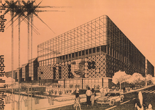
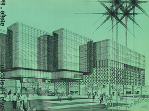
Figure 41a - View from Slavija Square Figure 41b - View from Maršala Tita Street (Kralja Milana)
Overview of the first prize-winning work at the Competition for Urban and Architectural Design for Slavija 1, authors - Studio "LIK", Belgrade
Source: Catalog of competition works
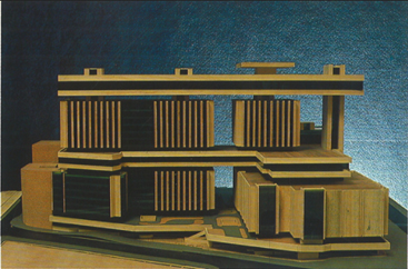
Picture 42a - Site view Figure 42b - Model - view from Maršala Tita Street (Kralja Milana)
Overview of one of the works on the Competition for Urban and Architectural Design Slavija 1, authors - Company for design, studies and consulting "Arhitekt", Arch. Božidar Hajdin
Source: Catalog of competition works
The DUP of the Slavija area from 1980 (Urban Institute of Belgrade, team leader Architect B. Stojkov) was the first comprehensive urban planning document at detailed planning level, for the area of Slavija with the contact area, following the Second World War. The DUP envisaged a fundamental reconstruction of the covered area with urban network enlargement and the formation, for the Belgrade level, of a significant zone of commercial contents located in the buildings GF + 2 to GF + 8. Below the traffic square, on four underground levels, a metro station was planned.
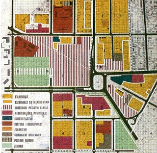
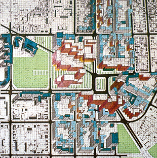
Figure 43a - DUP Slavija, Detailed purpose of surfaces Figure 43b - DUP Slavija, Possibility of continuing the trend
This plan initiated the announcement of several public architectural and urban competitions, which had a different fate in terms of implementation.
The competition for the urban and architectural solution of the area of Slavija Square and the surrounding blocks in Belgrade (2005) was announced as a public expert poll which would obtain the opinion of architects, urban planners and traffic experts and modern designs for building on the subject area. The authors of the first-prize-winning design, architects Tamara Petrović and Miloš Komlenić (within the CEP-Center for Urban Development Planning), defined the subject space's compositional solution clearly and consistently, forming a remodeled ambiance with new construction of approximately uniform height. The design affirms pedestrian movement by articulating existing potentially pedestrian areas, including a new regulatory route from Makenzijeva Street to Manjež Park, forming a new pedestrian route from Kralja Milana to Njegoševa Street and segregating pedestrian and stationary motor traffic located in the underground level.

Figure 44 - Competition from 2005, first prize, Arch. Tamara Petrović and Arch. Milos Komlenić, CEP
The competition (open, public, poll-based) for the development of urban and architectural design for the immediate zone of Slavija Square with a fountain (2012) was announced to cover the immediate zone of Slavija Square within the existing morphology and with the task of shaping the fountain in the central space (traffic flow center); traffic relief of the square by introducing underground pedestrian passages under certain streets as well as towards the center of the Square (fountain); urban square elements and lighting; possible relocation of the monument to Dimitrije Tucović to another location within the square (the participants in the competition propose the location) and a proposal for location arrangement. Four equal second prizes were awarded at the competition, explaining that all awarded works offer quality though partial answers.
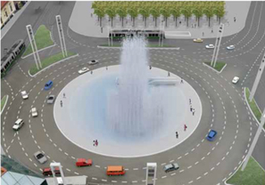
Figure 45a - second prize: G. Šišović, D. Milanović Figure 45b - second prize: V. Drecun, J. Mitrović, A.Bogdanović, L.Jevtić M.Folić, A.Hadžiahmetović
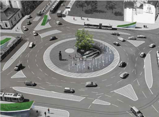
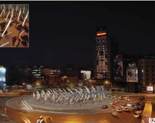
Figure 45c - second prize: N. Stevanović, V. Enbulajev, Figure 45g - second prize: Đ. Stojanović, M. Cerović,
V. Stevanović, MA A. Karabašević, M. Tasić, B. Obradović
Of the more significant competitions for urban and architectural design in the context of the development of locations in the contact area of this competition, we can also single out: Competition for social and business center between Slavija Square, Nemanjina, Svetozara Markovića and Kralja Milana Streets (1982) – erected National bank building (Figures 26 and 27); Competition for the conceptual urban and architectural design of the Dafiment Center commercial building (1992) for the so-called Mitić's hole space, the first prize for academician architect Milan Lojanić, and the Competition for architectural and urban design for the block between Kralja Milutina, Kralja Milana, Njegoševa and Svetozara Markovica streets (2006) - erected Hilton Belgrade hotel building (Pictures 30a and 30b)
In the competition documents, Annex IV - OTHER COMPETITION DOCUMENTS, the contents with more detailed data of the actual and planned development of the subject area are attached.
Natural characteristics of the space
The Belgrade climate is moderately continental, with four seasons and about 2,096 hours of sunshine a year. Precipitation is 669.5 mm on average per year. The highest number of days with precipitation is in April, June and December.
The subject area belongs to topoclimatic zone Center, which is characterized by an average annual temperature of 12.3 °C (mean minimum temperature January -1.3 °C, mean maximum temperature July 27.2 °C) in the total range of about -20.0 °C to about 40.0 °C, in extreme situations. The number of days with a temperature higher than 25 °C is 95 per year.
Belgrade is a windy area exposed to southeast, northeast, north and northwest winds. Silences are rare and most common during the summer. The most common and strongest is the southeast wind - Košava, which blows throughout the year, with a maximum in September and winter, with an average speed of 25 to 45 km/h, and storm surges up to 130 km/h to which, considering the orientation, competition area in Kralja Milutina and partly Kralja Milana Street is directly exposed. The coldest winter winds are north and northwest, to which the competition area is also directly exposed in the area of Svetozara Markovića Street.
Traffic characteristics of space
In terms of traffic, the immediate environment of the competition scope is extremely busy, with a high concentration of different types of traffic - car and pedestrian, and presence of all types of public transportation.
Street network
The block that is the subject of the competition is bordered by Kralja Milana, Svetozara Markovića, Nemanjina and Kralja Milutina Streets.
In the functional categorization of the existing street network, the mentioned roads are ranked as follows:
- Kralja Milana and Nemanjina streets - first order
- Kralja Milutina Street - second order
- Svetozara Markovića Street - part of the secondary traffic network
Kralja Milana Street, apart from belonging to the primary street network and representing the axis of the central Belgrade zone (Kalemegdan - Terazije - Slavija), in terms of the contents it serves, is a commercial and trade street. The road profile (27.0m in total) includes four lanes (two in each direction, 12.0m in total) and sidewalks with tree lines towards the road 8.0m wide on the side of the competition scope and 7.0m wide on the opposite side. The frequency of vehicle, public city and pedestrian traffic is continuously high.
Along Kralja Milana Street, there are no parking spaces in the zone of competition scope, nor the possibility of their establishment or vehicle access to the location.
Nemanjina Street, connects Slavija Square and Savski Square. The road profile (38.0m in total) includes: four lanes (two in each direction, 13.0m in total), a tram garden in the middle zone (7.5m) and sidewalks on both sides with tree lines 9.0m wide each. The frequency of traffic, primarily vehicle traffic, public city traffic is high during most of the day. Pedestrian traffic is frequent at the level of serving public city transportation and commercial, education and culture contents.
Along Nemanjina Street, parking is not planned within the competition scope.
Kralja Milutina Street, with a profile width of about 19.0m, includes two lanes (7.5m in total), and sidewalks 5.75m wide on each side. A two-sided parking space for longitudinal parking has been formed in the road profile in the current state.
Svetozara Markovića Street, in a profile of about 19.0 m, includes two lanes (8.0 in total), and sidewalks on both sides with tree lines 5.5 m wide each. A two-sided parking space for longitudinal parking has been formed in the current state in the road profile.
Kralja Milutina and Svetozara Markovića Streets are connected by an internal road - an intervention vehicle passage through the block within the National Bank of Serbia plot, towards the narrower competition scope.
Vehicle access to the National Bank of Serbia building and the entrance/exit to the related underground garage are provided from Nemanjina Street. Vehicle access to the plots within the competition scope is provided from Svetozara Markovića and Kralja Milutina streets. Vehicle access to the plots from Kralja Milana Street is not allowed.
The needs of stationary traffic for the existing contents in the block, except for the National Bank of Serbia and the new building at 45 Svetozara Markovića, solving the parking needs within the NBS underground garage and a dozen open parking spaces along the internal road, have not been met.
Pedestrian traffic
In the immediate vicinity of the competition scope, pedestrian movements are frequent, with intensity varying depending on the time of day, day of the week and period of the year. Pedestrian traffic takes place along both sidewalks of significant capacity in all peripheral streets, then in the zone of the newly formed piazzetta within Slavija Square and within the Manjež Park. The basic problem in creating continuity in pedestrian movements is inadequate connection of pedestrian areas. Within the competition scope, there are no areas intended for public pedestrian movement.
Public city passenger transportation
Thirteen lines of public city transport serve the subject area - bus lines and tram subsystem lines of public city transportation along Nemanjina Street, as well as bus and trolleybus transportation in Kralja Milana Street.
Cycling traffic
Along with the competition area itself, cycle path has been formed (by marking) only in Kralja Milutina Street.
Greenery and green areas
There are several categories of green areas in the environment and within the competition scope:
- greenery within public pedestrian areas - Manjež Park, park area in the area of Mitić's hole and greenery within Slavija Square
- linear greenery - tree lines
- block greenery
Linear greenery - tree lines
The regulation of all roads bordering the competition scope records street greenery in the form of tree lines.
In Kralja Milana and Nemanjina streets, these are continuous, reconstructed tree lines uniform in terms of composition and quality of trees, formed from grown seedlings, consisting mainly of ash trees about 15 cm in diameter and about 8 m high, at a distance of about 5 m.
The tree lines in Kralja Milutina and Svetozara Markovića streets represent the remains of a decades-old tree line, heterogeneous in terms of the trees' composition, age, and size.
Block greenery
The block interior has scarce free area capacities. Within the subject location, greenery is represented primarily through wild vegetation and there is no pronounced feature of the category. These are mostly single, wild trees, physiologically mature, with slightly poorer aesthetic and health characteristics, and belong to species such as sour wood, birch and maple.
Infrastructure
The water supply network of the subject area belongs to the II altitude zone of the city water supply. In the peripheral streets, the existing network includes lines Ø150 mm on the even number side of Kralja Milana Street, Ø 150 mm in Kralja Milutina Street, Ø 300 mm and Ø 100 mm in Svetozara Markovića Street and Ø 200 mm on the even number side of Nemanjina Street. The existing water supply network shall be retained with the planned capacity increase.
The sewerage network in the competition scope area belongs to the Central City Sewerage System, on which the sewerage is based according to the general sewerage principle and without planned changes. The final recipient for wastewater from this area is the existing collector OB 100/150 cm in Nemanjina Street.
The electricity network The existing electricity distribution network lines are underground. Existing roads are equipped with public lighting installations.
The hot water network of the subject area belongs to the heating system of the heating plant TO "Novi Beograd" (temperature and pressure regime 120/65 °C, NP16), i.e. to the hot water consumption of the existing main heating pipelines with diameters O355.6 / 5.6 mm, O273 / 6.3 and O219.1 / 315 mm laid in the corridor of Kralja Milutina and Nemanjina Streets.
The cadastral plan of underground installations is enclosed in the competition documents - II GRAPHIC DIGITAL PLANS.
Engineering and geological characteristics of the area
Geomorphologically speaking, the subject area belongs to a slope that descends from Kralja Aleksandra Boulevard. The microregion includes slope parts of the terrain with 5-15˚ inclination, and in some places, terrains with milder inclinations of 3-5˚ with terrain elevations of 111–117 m above sea level.
The geological substrate of the terrain is formed by tertiary sediments represented by limestones, marls and marly clays. The terrain has an embankment resulting from urbanization.
The subject terrain belongs to a single engineering geological region in terms of morphological characteristics uniformity, lithological composition and engineering and geological condition and properties of terrain and rock masses.
Groundwater is present in the terrain at depths of about 6-8 m, depending on the terrain hypsometric height.
The terrain is stable and waterless and can be used for urbanization. The construction of new urban facilities requires the adaptation of buildings to the slope, the manner and depth of foundation to be adjusted to the conditions of lithogenic environments to ensure protection against uneven subsidence. When arranging the terrain, acknowledge surface and groundwater with an appropriate system and regulate their runoff.
Current planning documents for the competition scope area
The planning basis for the area covered by the competition is the General Regulation Plan of the construction area of the seat of the local self-government unit - City of Belgrade unit I-XIX ("Official Gazette of the City of Belgrade" no. 20/16, 97/16, 69/17 and 97/17) hereinafter - Belgrade GRP.
In the area covered by the competition, the General Regulation Plan of the green areas of Belgrade ("Official Gazette of the City of Belgrade" No. 110/19) is also applied.
The detailed regulation plan for the block between Nemanjina, Svetozara Markovića, Kralja Milana (Srpskih vladara) and Kralja Milutina Streets ("Official Gazette of the City of Belgrade" 53/15), i.e. the urban design defined by this plan, does not represent the planning basis for the competition solution but is the subject of review within this competition. Considering that the decision was made to draft a new detailed regulation plan for this area, the drafting of which is the reason for announcing the competition, by adopting a new plan, the valid plan will be repealed.
General regulation plan – City of Belgrade
The subject area is located within the Central Zone and belongs to Unit I - Belgrade Center. Unit I - Belgrade Center, includes the historical center of Belgrade - "town in a trench", Terazije, Slavija, Svetosavski plateau, Belgrade port, Savski amphitheater and Prokop.
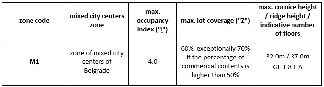
According to the Belgrade GRP, areas of other purposes are planned in the subject area, namely mixed city centers. According to the typology, the subject block is located in the M1 zone - the zone of mixed city centers in the Belgrade center zone.
Mixed city centers
Areas of mixed city centers in the central city zone, linear along the main roads or concentrated in the centers of urban subunits, are those in which commercial, business, and residential buildings with a business ground floor are planned.
In the existing buildings, the transformation of the ground floor, basement and possibly other floors into commercial and public facilities is planned on the mixed-use areas. New construction on individual plots implies constructing commercial and residential buildings with mandatory business facilities at least on the ground floor.
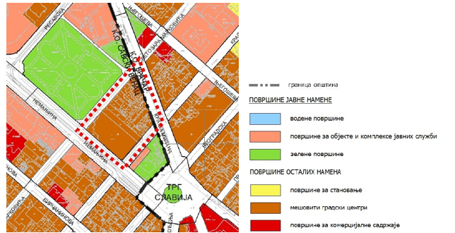
Figure 46 - Excerpt from Belgrade GRP, Planned land use
Zone of mixed city centers in the Belgrade center zone (M1)
This zone consists of blocks of the mixed city center in Unit I. The Belgrade center is characterized by peripheral construction in formed mixed purpose blocks. The combination of high housing, commercial and public facilities is characteristic of the Belgrade center zone, i.e. unit I, and makes up the predominant urban core.
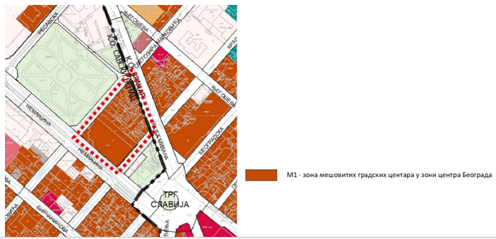
Figure 47 - Excerpt from Belgrade GRP, Division into zones with the same building rules
Traffic areas and primary traffic network
Unit I includes the central zone of the Šumadija part of the city and represents a unit with the densest road and street network in the territory.
This unit's primary road and street network comprises a large number of first-order streets and second-order streets, with main role of connecting the main entry routes and service contents in the subject area. The primary and secondary network of this unit is largely site and level defined.
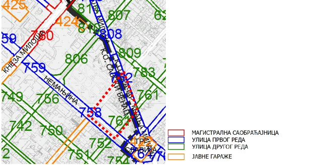
Figure 48 - Excerpt from Belgrade GRP, Traffic area
General regulation plan of green areas of Belgrade
The Belgrade system of green areas is planned in six spatial-functional units (components). The defined units represent areas with different representation and functional connection of existing and newly planned woods and green areas within a single system. They are key components for system sustainability.
The subject scope is located in the functional unit "Continuously built urban core."
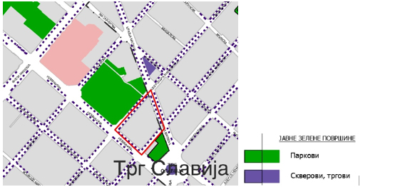
Figure 49 - Excerpt from the Belgrade green areas GRP, Planned green areas system
DRP for the block between Nemanjina, Svetozara Markovića, Kralja Milana (Srpskih vladara) and Kralja Milutina Streets ("Official Gazette of the City of Belgrade" 53/15)
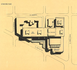
In this plan, the subject block space is divided into two urban units: unit A with commercial zone purpose and city centers and unit B with housing purpose in a compact urban block with commercial facilities.
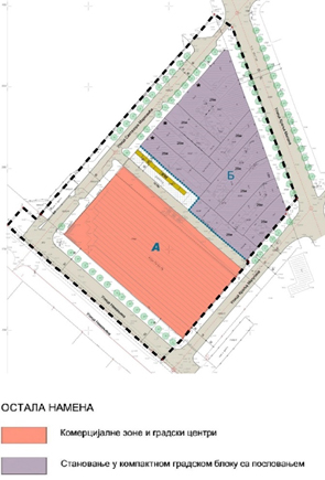
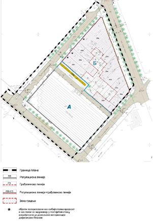
Figure 50a - Excerpt from the DRP, Planned purpose Figure 50b - Excerpt from the DRP, Regulation-leveling plan
Unit A is the National Bank of Serbia building at 17 Nemanjina street which, according to this plan, is to be retained in the current state and taken over as an inherited obligation.
Unit B consists of the remaining part of the block (narrower competition scope) in which construction of commercial facilities (min. 15% of GFA) is mandatory on the ground floors of the buildings. In this zone, the maximum occupancy index on the plot is 60% and the maximum building height (cornice) is 26m. Also, on the plots, it is necessary to provide a minimum of 15% of greenery from the total plot area, of which 10% in direct contact with the ground.
Individual buildings at 43, 47 and 49 Svetozara Markovića Street (marked* on the graphic attachment Regulation-leveling plan) represent a segment of the historical ambiance of Belgrade, valorized as ambient value and as such are to be retained with the possibility of reconstruction, restoration and revitalization, with allowed extension of existing buildings up to the maximum height defined by the subject plan (26 m) towards the interior of the plot in order to harmonize and connect the newly planned construction and the existing facilities within the block.
Excerpts from the current planning documents given within this chapter are informative, reference urban-parameter elements for the competition design are listed exclusively in Chapter 4. COMPETITION TASK and graphic attachment Limitations to the competition area given in the attachment to the competition documents INFORMATIVE GRAPHIC ATTACHMENT.
Excerpts from the current planning documents in the competition scope area are enclosed in the competition documents - IV EXCERPTS FROM VALID PLANNING DOCUMENTS.
Current planning documents in the contact zone of the competition scope
The area in the contact zone of the competiton scope is plan-determined by different levels of planning documents: Belgrade GRP, Belgrade green areas GRP and Detailed Regulation Plans:
- DRP of the area between the streets: Kralja Milana, Resavska, Nemanjina and Svetozara Markovića, CM Savski venac ("Official Gazette of the City of Belgrade" No. 11/19, 65/20 – as amended)
- DRP of Slavija Square, CM Vračar and Savski venac, ("Official Gazette of the City of Belgrade" No. 30/15, repealed in the part that is implemented directly by GRP Belgrade)
The Detailed Regulation Plan for the area between Kralja Milana, Beogradska, Njegoševa and Svetozara Markovića Streets (Decision on GRP drafting - "Official Gazette of the City of Belgrade" No. 138/19) is in the drafting phase, and for part of the contact area from the southwest side of Nemanjina Street, the GRP defines the mandatory development of a detailed regulation plan.
Excerpts from the current planning documents in the contact zone of the competition scope, as well as their boundaries, are enclosed in the competition documents - IV EXCERPTS FROM VALID PLANNING DOCUMENTS.